Encyclopedia/3. History, Societies & Civilizations/09. Modern Nations/01. Africa • Curated by Admin Timeline.sg
History of Sudan, sourced from Wikipedia's "Timeline of Sudanese history".
Chronological Storyline (23 Milestones)
975 CE
Makuria
Ibn Selim al-Aswani visits the Christian kingdoms of Makuria and Alodia, recording a comprehensive geopolitical and economic account of the Nubian courts. Source — Wikipedia, "Timeline of Sudanese history" (10th to 14th centuries):
This is the flag of the kingdom of Makuria according to the Spanish "Book of Knowledge of All Kingdoms". It dates to around 1350 and is therefore from the late Christian era of modern Sudan. By Unknown author - Libro del Conosçimiento de todos los rregnos, Public domain, https://commons.wikimedia.org/w/index.php?curid=115897568
1172 CE
Ayyubid dynasty
Ayyubid forces commanded by Turan-Shah invade Banu Kanz lands in Nubia, seizing the strategic frontier fortress of Qasr Ibrim. Source — Wikipedia, "Timeline of Sudanese history" (10th to 14th centuries):
View of the castle of Qasr Ibrim By Maxime Du Camp - [1], Public domain, https://commons.wikimedia.org/w/index.php?curid=171487349
1272 CE
Aidhab
King David of Makuria launches a military offensive against the Egyptian maritime port of Aidhab on the Red Sea coast. Source — Wikipedia, "Timeline of Sudanese history" (10th to 14th centuries):
1276 CE
Mamluk Sultanate
Mamluk forces under Sultan Baibars invade Makuria, capture Old Dongola, and displace King David to install a puppet ruler subject to tribute payments. Source — Wikipedia, "Timeline of Sudanese history" (10th to 14th centuries):
Map of the Mamluk sultanate during the third reign of al-Nasir Muhammad, 1317 AD, showing its political subdivisions and cities. Borders are approximate only. The primary resource used is the Encyclopedia of Islam, New Edition; see the articles regarding the various places, dynasties and individuals featured in the map. The articles on Diyar Mudar, al-Sa'id and Nuba were also referenced. Works cited: The Encyclopaedia of Islam. New Ed. 12 vols. with supplement and indices. Leiden: E.J. Brill, 1960-2005. "Europe in the Year 1300." Euratlas. Accessed 27 January 2016. Fakhry, Ahmed. The Oases of Egypt, Volume I: Siwa Oasis. Cairo: The American University at Cairo Press, 1973, pp. 96-97 (on the history of the Siwa Oasis). Holt, P.M. The Age of the Crusades: The Near East from the eleventh century to 1517. London: Routledge, 2013. ISBN 978-0-582-49302-5, pp. 133-36 (on Mamluk intervention in Makuria, along with the 1317 expedition to 'Aydab and Suakin). Holt, P.M. Early Mamluk Diplomacy (1260-1290): Treaties of Baybars & Qalawun with Christian Rulers. Leiden: E.J. Brill, 1995. ISBN 90-04-10246-9, pp. 74-78, 97-98 (copies of treaties which include lists of Mamluk territorial possessions). Al-Khazraji, 'Ali ibn al-Hasan. The Pearl-Strings; A History of the Resuliyy Dynasty of Yemen, Volume I. Trans. J.W. Redhouse. Ed. E.G. Browne, R.A. Nicholson and A. Rogers. Leyden: E.J. Brill, 1906 (on the history of the Yemen and Mecca). Nicolle, David. Mamluk 'Askari 1250-1517. Illus. Peter Dennis. Great Britain: Osprey Publishing, 2014. ISBN 978-1-4728-0352-8, p. 4 (containing map of the Mamluk sultanate). Peters, F.E. Mecca: A Literary History of the Muslim Holy Land. Princeton: Princeton University Press, 1994. ISBN 0-691-03267-X, pp. 148 ff. (on Mamluk activities in Mecca). Porter, Venetia Ann. The history and monuments of the Tahirid Dynasty of Yemen 858-923/1454-1517. PhD Thesis, Durham University, 1992, pp. 119 ff. (on the Mamluk intervention in the Yemen). Sinclair, T.A. Eastern Turkey: An Architectural and Archaeological Survey, Vol. IV. London: The Pindar Press, 1990, pp. 218-19 (on the status of Mamluk Jazira). Tsugitaka, Sato. State and Rural Society in Medieval Islam: Sultans, Muqta's and Fallahun. Leiden: E.J. Brill, 1997. ISBN 90-04-10649-9, pp. 135 ff. (regarding the rawk al-Nasiri; p. 138 contains the subdivisions of Egypt at this time); pp. 67-68 (on the oases of Egypt). Wiet, G. E.J. Brill's First Encyclopaedia of Islam, 1913-1936, Volume IV, 'Itk-Kwatta. Leiden: E.J. Brill, 1993. ISBN 90-04-09790-2, p. 904 (on the political status of the Wahat). Ziadeh, Nicola A. Urban life in Syria under the early Mamluks. Westport: Greenwood Press, 1953, pp 11-12 (on the administrative divisions of Syria). By Ro4444 - Own work, CC BY-SA 4.0, https://commons.wikimedia.org/w/index.php?curid=46642565
May 29, 1317 CE
The Throne Hall of Old Dongola
The Throne Hall of Old Dongola is formally converted into a mosque. Source — Wikipedia, "Timeline of Sudanese history" (10th to 14th centuries):
1323 CE
The Christian dynasties of Makuria effectively
The Christian dynasties of Makuria effectively disintegrated. Source — Wikipedia, "Timeline of Sudanese history" (10th to 14th centuries):
1504 CE
Funj Sultanate
The Funj Sultanate (Kingdom of Sennar) is founded by Amara Dunqas following the final collapse of the tribal monarchy of Alodia. Source — Wikipedia, "Timeline of Sudanese history" (15th to 18th centuries):
Map of the Funj Sultanate in around 1700 AD, just before the revolt of the Shaiqiya. Based on Jay Spaulding (1985): "The Heroic Age in Sennar", but slightly modified. By LeGabrie - Own work, CC BY-SA 4.0, https://commons.wikimedia.org/w/index.php?curid=74912509
1612 CE
Sultanate of Darfur
The Keira dynasty consolidates the Sultanate of Darfur under Sulayman Solong, establishing Islam as the official state religion. Source — Wikipedia, "Timeline of Sudanese history" (15th to 18th centuries):
Map of Darfur in July 1914 By Koopinator - Own work, CC BY-SA 4.0, https://commons.wikimedia.org/w/index.php?curid=80321471
1744 CE
Battle of the Dindar River
Battle of the Dindar River: The Funj Sultanate successfully repels a major invasion army launched by the Ethiopian Empire under Emperor Iyasu II. Source — Wikipedia, "Timeline of Sudanese history" (15th to 18th centuries):
Engraved by Guillaume Delahaye. By Jean Baptiste Bourguignon d'Anville - UTA Libraries Cartographic Connections: map / text, Public domain, https://commons.wikimedia.org/w/index.php?curid=186649166
1762 CE
The Hamaj Coup occurs as military
The Hamaj Coup occurs as military commander Muhammad Abu Likaylik overthrows the ruling Funj monarch, instating the Hamaj Regency and precipitating internal state decay. Source — Wikipedia, "Timeline of Sudanese history" (15th to 18th centuries):
1881 CE
Mahdist War
Mahdist War: A war began against the United Kingdom and Egypt Source — Wikipedia, "Timeline of Sudanese history" (19th century):
A collage of major battles in the Mahdist/Sudan War By Fidodog14 - Own work, CC0, https://commons.wikimedia.org/w/index.php?curid=151780303
1899 CE
United Kingdom of Great Britain and Ireland
Sudan fell under the rule of an Anglo-Egyptian condominium. Source — Wikipedia, "Timeline of Sudanese history" (19th century):
Flag of the United Kingdom, Union Jack or Union Flag in a 1:2 ratio (typical on British warships and also the rank flag of an admiral of the fleet). By Original: Acts of Union 1800 Vector: Zscout370 - Own work based on: United Kingdom at Flag of the World United Kingdom Flag at the Flag Institute, Public domain, https://commons.wikimedia.org/w/index.php?curid=347935
1955 CE
First Sudanese Civil War
First Sudanese Civil War begins Source — Wikipedia, "Timeline of Sudanese history" (20th century):
(en) Sudan Location (he) מיקום סודן By By Rei-artur pt en Rei-artur blog - Original by User:Vardion, Image:A large blank world map with oceans marked in blue.svg, CC BY-SA 3.0, https://commons.wikimedia.org/w/index.php?curid=1446548
1956 CE
The country becomes independent as the
The country becomes independent as the Republic of the Sudan Source — Wikipedia, "Timeline of Sudanese history" (20th century):
1983 CE
Second Sudanese Civil War
Second Sudanese Civil War begins Source — Wikipedia, "Timeline of Sudanese history" (20th century):
Aug 20, 1998 CE
Al-Shifa pharmaceutical factory
Al-Shifa pharmaceutical factory destroyed in a missile strike by the United States Source — Wikipedia, "Timeline of Sudanese history" (20th century):
KH-11 photo of the Shifa Pharmaceutical Plant, Sudan By U.S. Department of Defense - http://www.centennialofflight.gov/essay/SPACEFLIGHT/recon/SP38G5.htm, Public domain, https://commons.wikimedia.org/w/index.php?curid=12708262
Feb 1, 2001 CE
Hassan al-Turabi
Al-Turabi was arrested for signing a memorandum with the SPLA. Source — Wikipedia, "Timeline of Sudanese history" (21st century):
Hassan Al Turabi (1 February 1932 – 5 March 2016) , Islamist leader, in his private home in Shambat, Khartoum, Sudan, one year before his death By RomanDeckert - Own work, CC BY-SA 4.0, https://commons.wikimedia.org/w/index.php?curid=66094298
Jan 1, 2002 CE
Sudan People's Liberation Army
A ceasefire was agreed between the government and the SPLA. Source — Wikipedia, "Timeline of Sudanese history" (21st century):
Flag used by the Sudan People's Liberation Army since 2011. By MrPenguin20 - Own work. Flag can be seen here., CC BY-SA 3.0, https://commons.wikimedia.org/w/index.php?curid=30189604
Feb 1, 2003 CE
War in Darfur
War in Darfur: The war began. Source — Wikipedia, "Timeline of Sudanese history" (21st century):
Map of Darfur within Sudan, July 2011. By Sudan location map.svg: NordNordWest Map of Darfur-en.png: User:Пакко This derivative image: Idaltu - Sudan location map.svgMap of Darfur-en.png, CC BY-SA 3.0, https://commons.wikimedia.org/w/index.php?curid=15742605
Jan 1, 2004 CE
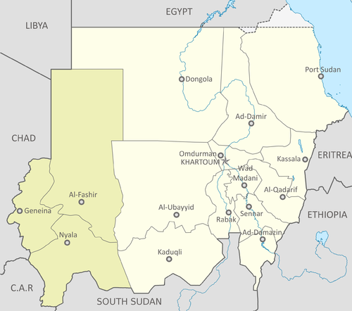
Darfur
The army moved into Darfur to quell the rebellion, prompting hundreds of thousands of refugees to flee into neighbouring Chad. Source — Wikipedia, "Timeline of Sudanese history" (21st century):
5 states part of darfur highlighted. By Unknown author - Sudan location map.svg, CC BY-SA 3.0, https://commons.wikimedia.org/w/index.php?curid=188486404
Jan 9, 2005 CE
Comprehensive Peace Agreement
The Comprehensive Peace Agreement was signed between the SPLA and the government. Source — Wikipedia, "Timeline of Sudanese history" (21st century):
Map showing political regions of Sudan as of July 2006. By Lokal_Profil - Information based on Political Regions of Sudan (CPA).png by Сержант Кандыба Vector map from Blank map of Sudan administrative areas.svg by Maplibrary.org Information from Sudan political regions July 2006.png by Kwamikagami which in turn is based on Sudan politicaly distrikt map Jul2006.png by Orthuberra Combined by Lokal_Profil, CC BY-SA 2.5, https://commons.wikimedia.org/w/index.php?curid=15748011
May 1, 2006 CE
Darfur
The government signed a peace accord with a Darfur rebel group, the Sudan Liberation Movement. Source — Wikipedia, "Timeline of Sudanese history" (21st century):
5 states part of darfur highlighted. By Unknown author - Sudan location map.svg, CC BY-SA 3.0, https://commons.wikimedia.org/w/index.php?curid=188486404
May 1, 2007 CE
United States
The United States placed fresh sanctions on Sudan. Source — Wikipedia, "Timeline of Sudanese history" (21st century):
The Flag of the United States of America. Taken from the revision of Flag of the United States, created on April 4, 2007, based on the above flag law as amended by Executive Order No. 10834 dated August 21, 1959. Color specifications Official regulation: General Services Administration "Federal Specification, Flag, National, United States of America and Flag, Union Jack," DDD-F-416E.[1] This regulation is dated November 27, 1981. The colors are specified by reference to the "Standard Color Cards of America" maintained by the Color Association of the United States, Inc. These colors are: Cable No. 70180 Old Glory Red Cable No. 70001 White Cable No. 70075 Old Glory Blue When matched with Pantone specification provided by government agencies[2][3][4][5], these colors are: Old Glory Red: (PMS 193C) White Old Glory Blue: (PMS 281C) When converted to RGB, these colors are: Old Glory Red: #BF0A30 White: #FFFFFF Old Glory Blue: #00205B By Vector file created by Dbenbenn, Zscout370, Jacobolus, Indolences, and Technion. - SVG implementation of U. S. Code: Title 4, Chapter 1, Section 1, Public domain, https://commons.wikimedia.org/w/index.php?curid=167150371




![The Flag of the United States of America. Taken from the revision of Flag of the United States, created on April 4, 2007, based on the above flag law as amended by Executive Order No. 10834 dated August 21, 1959. Color specifications Official regulation: General Services Administration "Federal Specification, Flag, National, United States of America and Flag, Union Jack," DDD-F-416E.[1] This regulation is dated November 27, 1981. The colors are specified by reference to the "Standard Color Cards of America" maintained by the Color Association of the United States, Inc. These colors are: Cable No. 70180 Old Glory Red Cable No. 70001 White Cable No. 70075 Old Glory Blue When matched with Pantone specification provided by government agencies[2][3][4][5], these colors are: Old Glory Red: (PMS 193C) White Old Glory Blue: (PMS 281C) When converted to RGB, these colors are: Old Glory Red: #BF0A30 White: #FFFFFF Old Glory Blue: #00205B](https://upload.wikimedia.org/wikipedia/commons/thumb/9/96/Flag_of_the_United_States_%28DDD-F-416E_specifications%29.svg/500px-Flag_of_the_United_States_%28DDD-F-416E_specifications%29.svg.png)