Encyclopedia/3. History, Societies & Civilizations/09. Modern Nations/01. Africa • Curated by Admin Timeline.sg
History of Mauritania (AI-generated, sourced to Wikipedia).
Chronological Storyline (28 Milestones)
200 BCE
Berber peoples migrate west
Berber groups migrated into the western Sahara region, establishing pastoral and nomadic communities that would form the demographic foundation of Mauritania. Source — Wikipedia, "Mauritania":
“Berber flag”. Originally created by the Berber Academy (Agraw Imazighen) in the 70s, the flag was adopted in 1998 flag of the Berber people by the Amazigh World Congress (CMA, Agraw Amadlan Amazigh). The “ⵣ” symbol is a Tifinagh letter called "yaz" and pronounced [z]. By Mysid - Drawn by Mysid in CorelDraw, based on a GIF uploaded on en-wiki by Skafis on March 5, 2006., Public domain, https://commons.wikimedia.org/w/index.php?curid=5566983
300 CE
Ghana Empire extends influence
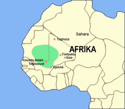
The Ghana Empire expanded its influence into southeastern Mauritania, controlling trans-Saharan trade routes and gold commerce across the Sahel. Source — Wikipedia, "Mauritania":
Map of the Ghana Empire. (German version) By Luxo - Image:BlankMap-World gray.svg, CC BY-SA 3.0, https://commons.wikimedia.org/w/index.php?curid=1097270
1040 CE
Almoravid movement founded
The Almoravid religious and military movement emerged in the Mauritanian desert, uniting Sanhaja Berber tribes under a strict Islamic reformist ideology. Source — Wikipedia, "Mauritania":
Mapa de la expansión almorávide, según datos de ISBN 9788433824516. By Rowanwindwhistler - Own work Base map (coast, territory, rivers...) from Natural Earth Location of towns from Wikipedia Projection: Africa Lambert conformal conic, CC BY-SA 4.0, https://commons.wikimedia.org/w/index.php?curid=50658698
1076 CE
Almoravids conquer Ghana
Almoravid forces captured the Ghana Empire's capital at Kumbi Saleh, extending their control over a vast territory stretching from the Sahara into Spain. Source — Wikipedia, "Mauritania":
Flag of Mauritania, adopted in 2017. The National Assembly added red stripes to the top and bottom edges to represent “the blood shed by the martyrs of independence”. By See File history below for details. - Own work, based on this governmental website: http://www.kennach.gov.mr/drapeau. See also: Flags of the World - Mauritania, construction sheet http://www.kennach.gov.mr/docs/plan01.pdf http://www.kennach.gov.mr/documents, Public domain, https://commons.wikimedia.org/w/index.php?curid=57054820
1276 CE
Chinguetti founded as trade hub
Chinguetti was established as a major trans-Saharan caravan trading center and Islamic scholarly city, later becoming a UNESCO World Heritage Site. Source — Wikipedia, "Mauritania":
Vue Generale de la vieille ville de Chinguetti en Mauritanie By François COLIN - Own work, CC BY-SA 2.5, https://commons.wikimedia.org/w/index.php?curid=1330737
1455 CE
Portuguese reach Mauritanian coast
Portuguese explorers arrived on the Mauritanian Atlantic coast, initiating European contact and the gum arabic trade with local emirates. Source — Wikipedia, "Mauritania":
Image pasted from 27 detailed frames by using Adobe Photoshop. Frames to be found at: http://www.cedoc.mo.it/estense/img/geo/Cantino/index.html By The original uploader was Joopr at English Wikipedia. - Transferred from en.wikipedia to Commons by Quadell using CommonsHelper., Public domain, https://commons.wikimedia.org/w/index.php?curid=6411115
1640 CE
Emirate of Trarza established
The Emirate of Trarza was founded by Arab Beni Hassan tribes, becoming one of several emirates that dominated southern Mauritania through the colonial era. Source — Wikipedia, "Mauritania":
Map includes a scale, compass, subdivisions of Trarza, the Gambia River, neighboring states and an inset map of the Senegambia Region ca.1850. Sources for Trarza are as follows: For coastline and rivers, made with Natural Earth. For Senegalese kingdoms north of the Gambia: Atlas national du Sénégal. (1977). Institut géographique international. P.57. For Mauritania: Choplin, A., & Ould Bah, M. F. (2018). Foncier, droit et propriété : au cœur de la société mauritanienne. Centre Jacques-Berque. https://doi.org/10.4000/books.cjb.1277. Map.1. For other non-Mauritanian kingdoms, plus European forts: The West Coast of Africa. (n.d.). Www.davidrumsey.com. Retrieved January 13, 2024, from https://www.davidrumsey.com/luna/servlet/detail/RUMSEY~8~1~2768~270041:The-West-Coast-of-Africa-?sort=pub_list_no_initialsort%2Cpub_list_no_initialsort%2Cpub_date%2Cpub_date&qvq=w4s:/what%2FAtlas%2BMap Additional sources for the inset map are as follows: For Senegalese kingdoms south of the Gambia: Quinn, C. A. (1972). Mandingo Kingdoms of the Senegambia. P.IX-X For the Ceded Mile (Gambia): Hughes, A., & Perfect, D. (2008). Historical Dictionary of The Gambia. Scarecrow Press. P.XVIII & 33. For Buje (in Casamance): Roche, Christian. (1985). Histoire de la Casamance : conquête et résistance : 1850-1920. Karthala. P105. By HetmanTheResearcher - Own work, CC BY 4.0, https://commons.wikimedia.org/w/index.php?curid=144625256
1902 CE
French colonization begins
French colonial administrator Xavier Coppolani launched military and diplomatic campaigns to subjugate the Mauritanian emirates, beginning French domination of the territory. Source — Wikipedia, "Mauritania":
Xavier Coppolani : reproduction de portrait By Agence Rol - Bibliothèque nationale de France, Public domain, https://commons.wikimedia.org/w/index.php?curid=10100309
1904 CE
Mauritania declared French territory
France formally established the Civil Territory of Mauritania, consolidating its control over the region despite ongoing armed resistance from local emirates. Source — Wikipedia, "Mauritania":
Flag of Mauritania, adopted in 2017. The National Assembly added red stripes to the top and bottom edges to represent “the blood shed by the martyrs of independence”. By See File history below for details. - Own work, based on this governmental website: http://www.kennach.gov.mr/drapeau. See also: Flags of the World - Mauritania, construction sheet http://www.kennach.gov.mr/docs/plan01.pdf http://www.kennach.gov.mr/documents, Public domain, https://commons.wikimedia.org/w/index.php?curid=57054820
1920 CE
Incorporated into French West Africa
Mauritania was administratively integrated into French West Africa, remaining one of the least developed and most isolated territories in the colonial federation. Source — Wikipedia, "Mauritania":
Flag of France By Original: Unknown Vector: SKopp - This SVG flag includes elements that have been taken or adapted from this flag:, Public domain, https://commons.wikimedia.org/w/index.php?curid=60739584
1946 CE
Becomes overseas territory
Mauritania was reclassified as a French overseas territory, granting limited political representation and laying groundwork for future independence movements. Source — Wikipedia, "Mauritania":
Flag of France By Original: Unknown Vector: SKopp - This SVG flag includes elements that have been taken or adapted from this flag:, Public domain, https://commons.wikimedia.org/w/index.php?curid=60739584
Mar 1, 1957 CE
Nouakchott chosen as capital
The small village of Nouakchott was selected as the future capital of Mauritania, chosen for its central location and potential for development. Source — Wikipedia, "Mauritania":
Nouakchott is situated on the coast of the Atlantic Ocean and has been the capital of Mauritania since 1957 By Laminesall96 - Own work, CC BY-SA 4.0, https://commons.wikimedia.org/w/index.php?curid=58485797
Nov 28, 1960 CE
Independence from France
Mauritania gained full independence from France under President Moktar Ould Daddah, becoming one of the last African nations to achieve sovereignty. Source — Wikipedia, "Mauritania":
Flag of Mauritania, adopted in 2017. The National Assembly added red stripes to the top and bottom edges to represent “the blood shed by the martyrs of independence”. By See File history below for details. - Own work, based on this governmental website: http://www.kennach.gov.mr/drapeau. See also: Flags of the World - Mauritania, construction sheet http://www.kennach.gov.mr/docs/plan01.pdf http://www.kennach.gov.mr/documents, Public domain, https://commons.wikimedia.org/w/index.php?curid=57054820
Oct 1, 1961 CE
Joins United Nations
Mauritania was admitted to the United Nations, securing international recognition despite initial opposition from Morocco which claimed the territory. Source — Wikipedia, "Mauritania":
Flag of Mauritania, adopted in 2017. The National Assembly added red stripes to the top and bottom edges to represent “the blood shed by the martyrs of independence”. By See File history below for details. - Own work, based on this governmental website: http://www.kennach.gov.mr/drapeau. See also: Flags of the World - Mauritania, construction sheet http://www.kennach.gov.mr/docs/plan01.pdf http://www.kennach.gov.mr/documents, Public domain, https://commons.wikimedia.org/w/index.php?curid=57054820
1963 CE
Iron ore mining begins
Large-scale iron ore extraction commenced at the Fderik-Zouerate mines, transforming Mauritania's economy and making iron its primary export commodity. Source — Wikipedia, "Mauritania":
Flag of Mauritania, adopted in 2017. The National Assembly added red stripes to the top and bottom edges to represent “the blood shed by the martyrs of independence”. By See File history below for details. - Own work, based on this governmental website: http://www.kennach.gov.mr/drapeau. See also: Flags of the World - Mauritania, construction sheet http://www.kennach.gov.mr/docs/plan01.pdf http://www.kennach.gov.mr/documents, Public domain, https://commons.wikimedia.org/w/index.php?curid=57054820
Nov 14, 1975 CE
Madrid Accords signed
Spain, Morocco, and Mauritania signed the Madrid Accords, dividing the Spanish Sahara and granting Mauritania control over the southern portion. Source — Wikipedia, "Mauritania":
Madrid Accords or the Declaration of Principles on Western Sahara, a 1975 treaty document By United Nations Treaty series - https://peacemaker.un.org/sites/peacemaker.un.org/files/MA-MR-ES_751114_DeclarationPrinciplesOnWesternSahara_0.pdf, Public domain, https://commons.wikimedia.org/w/index.php?curid=115746665
Jan 1, 1976 CE
Western Sahara War begins
The Polisario Front launched guerrilla attacks against Mauritanian forces in the newly annexed Tiris al-Gharbiyya region, draining the national economy. Source — Wikipedia, "Mauritania":
This is a general map of Western Sahara. The Polisario Front controls the area to the east of the berm, while Morocco controls the area to the west. By Kmusser - Own work based primarily on the Digital Chart of the World, with this UN map and commercial atlases (Rand McNally, Google, Encarta, and National Geographic) used as references., CC BY-SA 2.5, https://commons.wikimedia.org/w/index.php?curid=1621025
Jul 10, 1978 CE
Military coup ousts Daddah
Army officers led by Colonel Mustafa Ould Salek overthrew President Moktar Ould Daddah, ending civilian rule amid economic collapse from the Sahara war. Source — Wikipedia, "Mauritania":
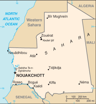
Map of Mauritania showing major cities. By CIA - CIA, The World Factbook, 2004, Public domain, https://commons.wikimedia.org/w/index.php?curid=89492
Aug 5, 1979 CE
Peace with Polisario Front
Mauritania signed a peace agreement with the Polisario Front, renouncing all claims to Western Sahara and withdrawing from the conflict. Source — Wikipedia, "Mauritania":
Gathering of Saharawi troops, near Tifariti (Western Sahara), celebrating the 32nd anniversary of the Polisario Front. By Saharauiak - originally posted to Flickr as Soldadu saharauiak - Polisario troops, CC BY-SA 2.0, https://commons.wikimedia.org/w/index.php?curid=1294535
Jul 1, 1981 CE
Slavery officially abolished
The Mauritanian government formally abolished slavery, though the practice persisted in practice and would remain a major human rights issue for decades. Source — Wikipedia, "Mauritania":
Flag of Mauritania, adopted in 2017. The National Assembly added red stripes to the top and bottom edges to represent “the blood shed by the martyrs of independence”. By See File history below for details. - Own work, based on this governmental website: http://www.kennach.gov.mr/drapeau. See also: Flags of the World - Mauritania, construction sheet http://www.kennach.gov.mr/docs/plan01.pdf http://www.kennach.gov.mr/documents, Public domain, https://commons.wikimedia.org/w/index.php?curid=57054820
Dec 1, 1984 CE
Taya seizes power in coup
Army chief Colonel Maaouya Ould Sid'Ahmed Taya seized power in a bloodless coup, ruling Mauritania for over two decades through authoritarian governance. Source — Wikipedia, "Mauritania":
Maaouya Ould Sid'Ahmed Taya (*1943) was president of Mauritania 1984-2005, this is a photograph of a sign in Mauritania, with a photo of then President Taya. By VOA News - Voa News, US Government, not tagged as a wire photo, removed from english language archive article, but still available at http://www.voanews.com/korean/images/mauritania_gov_ould_taya_210_eng_30apr05.jpg, Public domain, https://commons.wikimedia.org/w/index.php?curid=3772540
Apr 1, 1989 CE
Mauritania-Senegal Border War
A dispute over grazing rights escalated into ethnic violence between Mauritania and Senegal, causing mass expulsions of each country's nationals across the border. Source — Wikipedia, "Mauritania":
NASA image of Senegal river By NASA, uploaded by Laurens - Image ISS002-E-5456 2 of USGov-NASA, Public domain, https://commons.wikimedia.org/w/index.php?curid=476691
Jul 20, 1991 CE
New constitution adopted
A new constitution establishing a multiparty system was approved by referendum, though subsequent elections were widely criticized as fraudulent. Source — Wikipedia, "Mauritania":
Seal of Mauritania By Jelloud Najem - Own work, Public domain, https://commons.wikimedia.org/w/index.php?curid=75463118
Aug 3, 2005 CE
Bloodless coup ousts Taya
Military officers led by Ely Ould Mohamed Vall overthrew President Taya while he was abroad, promising a transition to democratic civilian rule. Source — Wikipedia, "Mauritania":
Map of Mauritania showing major cities. By CIA - CIA, The World Factbook, 2004, Public domain, https://commons.wikimedia.org/w/index.php?curid=89492
Mar 11, 2007 CE
First democratic election
Sidi Ould Cheikh Abdallahi won Mauritania's first fully democratic presidential election, marking a peaceful transition from military to civilian governance. Source — Wikipedia, "Mauritania":
Sidi Mohamed Ould Cheikh Abdallahi By Marcello Casal Jr./Abr - http://www.agenciabrasil.gov.br/media/imagens/2007/09/27/1254MCMauritania1.jpg/view, CC BY 3.0 br, https://commons.wikimedia.org/w/index.php?curid=3297660
Aug 6, 2008 CE
Coup ousts elected president
General Mohamed Ould Abdel Aziz overthrew President Abdallahi in a military coup, returning Mauritania to authoritarian military rule. Source — Wikipedia, "Mauritania":
www.magharebia.com/cocoon/awi/xhtml1/en_GB/special_covera... www.magharebia.com/cocoon/awi/xhtml1/ar/special_coverage_... www.magharebia.com/cocoon/awi/xhtml1/fr/special_coverage_... By Magharebia - 080807 Mauritanian Soldiers After the Coup | Les soldats mauritaniens Après le coup | جنود موريتانيين بعد الانقلاب, CC BY 2.0, https://commons.wikimedia.org/w/index.php?curid=18252035
Aug 1, 2015 CE
Slavery criminalized
Mauritania passed a law making slavery a crime against humanity with penalties of up to 20 years imprisonment, though enforcement remained limited. Source — Wikipedia, "Mauritania":
Flag of Mauritania, adopted in 2017. The National Assembly added red stripes to the top and bottom edges to represent “the blood shed by the martyrs of independence”. By See File history below for details. - Own work, based on this governmental website: http://www.kennach.gov.mr/drapeau. See also: Flags of the World - Mauritania, construction sheet http://www.kennach.gov.mr/docs/plan01.pdf http://www.kennach.gov.mr/documents, Public domain, https://commons.wikimedia.org/w/index.php?curid=57054820
Aug 1, 2019 CE
First peaceful democratic transition
Mohamed Ould Ghazouani was inaugurated as president, marking Mauritania's first peaceful transfer of power between elected leaders since independence. Source — Wikipedia, "Mauritania":
Map showing the results of the 2019 Mauritanian presidential election per wilaya and moughataa (department). By Tidjani Saleh - Own work, CC BY-SA 4.0, https://commons.wikimedia.org/w/index.php?curid=117447605
![“Berber flag”. Originally created by the Berber Academy (Agraw Imazighen) in the 70s, the flag was adopted in 1998 flag of the Berber people by the Amazigh World Congress (CMA, Agraw Amadlan Amazigh). The “ⵣ” symbol is a Tifinagh letter called "yaz" and pronounced [z].](https://upload.wikimedia.org/wikipedia/commons/thumb/e/ec/Berber_flag.svg/500px-Berber_flag.svg.png)