Encyclopedia/3. History, Societies & Civilizations/09. Modern Nations/01. Africa • Curated by Admin Timeline.sg
History of Djibouti (AI-generated, sourced to Wikipedia).
Chronological Storyline (30 Milestones)
2500 BCE
Land of Punt referenced
Ancient Egyptian records describe the Land of Punt, a trading partner in the Horn of Africa region encompassing modern Djibouti. Source — Wikipedia, "Djibouti":
Map of the Middle East 1450 BC (by ArdadN) By ArdadN at English Wikipedia - The original description page was here. All following user names refer to en.wikipedia., Public domain, https://commons.wikimedia.org/w/index.php?curid=4531618
900 CE
Islam spreads to region
Islam reaches the Horn of Africa through Arab and Persian merchants along the Red Sea and Gulf of Aden coasts. Source — Wikipedia, "Djibouti":
Flag of Djibouti By Unknown author - From the Open Clip Art website., Public domain, https://commons.wikimedia.org/w/index.php?curid=433103
1285 CE
Ifat Sultanate rises
The Walashma dynasty establishes the Ifat Sultanate, a Muslim state controlling trade routes across the Horn of Africa. Source — Wikipedia, "Djibouti":
The Sultanate of Ifat at its height. By Skilla1st - Own work, CC BY-SA 4.0, https://commons.wikimedia.org/w/index.php?curid=78811638
1415 CE
Adal Sultanate established
The Adal Sultanate emerges as a powerful Islamic state centered in the Horn of Africa, succeeding the Ifat Sultanate. Source — Wikipedia, "Djibouti":
Flag of Adal Sultanate. By FDRMRZUSA - Own work, based on the description of Castanhoso: "...the king of Zeila [Imam Ahmad] ascended a hill with several horse and some foot to examine us: he halted on the top with three hundred horse and three large banners, two white with red moons, and one red with a white moon, which always accompanied him, and [by] which he was recognized." (Extracted from: The Portuguese expedition to Abyssinia in 1541-1543, page 41 at [1]).WARNING: This image is highly speculative and should not be added to articles about the Mongol Empire. If it is added anyway, then its speculative nature must be a clearly indicated., Public domain, https://commons.wikimedia.org/w/index.php?curid=83901220
1527 CE
Adal-Ethiopian war begins
Imam Ahmad ibn Ibrahim al-Ghazi of Adal launches a major war against the Ethiopian Empire, devastating the highlands. Source — Wikipedia, "Djibouti":
Hailu of Gondar, Kegneketa Jemlieri; The Defeat of Ahmed Gran by King Claudius on 21 February 1543; Horniman Museum and Gardens; http://www.artuk.org/artworks/the-defeat-of-ahmed-gran-by-king-claudius-on-21-february-1543-194066 By Horniman Museum, London, UK. Photographic Rights The Bridgeman Art Library - Kegneketa Jemlieri Hailu of Gondar (fl.1900), CC0, https://commons.wikimedia.org/w/index.php?curid=160281676
1577 CE
Aussa Sultanate founded
The Aussa Sultanate is established in the Afar region, becoming a significant local power that persists into the 20th century. Source — Wikipedia, "Djibouti":
Aussa on modern map By Sémhur - File:Ethiopia (Africa orthographic projection).svg, CC BY-SA 3.0, https://commons.wikimedia.org/w/index.php?curid=121443156
1862 CE
France acquires Obock
France purchases the port of Obock from local Afar sultans, establishing its first foothold in the region. Source — Wikipedia, "Djibouti":
Obock, Djibouti 2010 By Luc Michel - Own work, CC BY-SA 3.0, https://commons.wikimedia.org/w/index.php?curid=28897250
1883 CE
French treaties signed
France signs protectorate treaties with Issa and Afar chiefs, expanding its influence along the Gulf of Tadjoura coast. Source — Wikipedia, "Djibouti":
Flag of France By Original: Unknown Vector: SKopp - This SVG flag includes elements that have been taken or adapted from this flag:, Public domain, https://commons.wikimedia.org/w/index.php?curid=60739584
1888 CE
Djibouti city founded
The French establish the city of Djibouti as the capital of their new colonial territory, replacing Obock as the main port. Source — Wikipedia, "Djibouti":
Montage of places in Djibouti City, Djibouti. By Middayexpress (derivative work) - Top row, from left: File:Djibheron.jpg File:Djibmes.jpg (top) File:Djibruemar.jpg (bottom) Bottom row, from left: File:Djibhotimp.jpg (top) File:Djibrueven.jpg (bottom) File:Djibplamar.jpg, CC BY-SA 4.0, https://commons.wikimedia.org/w/index.php?curid=35209722
1896 CE
French Somaliland created
France formally organizes its holdings as the Côte française des Somalis (French Somaliland), a colony administered from Djibouti. Source — Wikipedia, "Djibouti":
Flag of France By Original: Unknown Vector: SKopp - This SVG flag includes elements that have been taken or adapted from this flag:, Public domain, https://commons.wikimedia.org/w/index.php?curid=60739584
1917 CE
Railway to Addis Ababa
The Djibouti–Addis Ababa railway is completed, linking the port of Djibouti to the Ethiopian highlands and boosting trade. Source — Wikipedia, "Djibouti":
The map of Addis Ababa-Djibouti Railway. By Skilla1st - Own work, CC BY-SA 4.0, https://commons.wikimedia.org/w/index.php?curid=49435448
Jul 1, 1940 CE
Vichy control established
Following France's defeat in World War II, French Somaliland comes under Vichy French administration aligned with the Axis powers. Source — Wikipedia, "Djibouti":
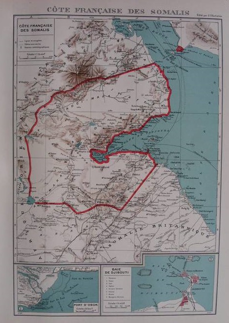
Map of French Somaliland, from the Atlas colonial français published by L'Illustration (1938 edition). On the other side of the Strait of Bab el-Mandeb, Cheik-Saïd is clearly shown as a French possession, although it was not. This map shows the new Italian Eritrea-French Somaliland border as per the Laval-Mussolini Accord of January 1935. After WWII, the border was pushed back north, to what it had been before 1935. By Édition L'Illustration, 1938 - Delcampe.net auction, Public domain, https://commons.wikimedia.org/w/index.php?curid=35265977
Dec 1, 1942 CE
Free French liberation
British and Free French forces liberate Djibouti from Vichy control, bringing the territory into the Allied war effort. Source — Wikipedia, "Djibouti":
Map of French Somaliland, from the Atlas colonial français published by L'Illustration (1938 edition). On the other side of the Strait of Bab el-Mandeb, Cheik-Saïd is clearly shown as a French possession, although it was not. This map shows the new Italian Eritrea-French Somaliland border as per the Laval-Mussolini Accord of January 1935. After WWII, the border was pushed back north, to what it had been before 1935. By Édition L'Illustration, 1938 - Delcampe.net auction, Public domain, https://commons.wikimedia.org/w/index.php?curid=35265977
1946 CE
Overseas territory status
French Somaliland is reclassified as a French overseas territory, granting limited political representation to its inhabitants. Source — Wikipedia, "Djibouti":
Flag of France By Original: Unknown Vector: SKopp - This SVG flag includes elements that have been taken or adapted from this flag:, Public domain, https://commons.wikimedia.org/w/index.php?curid=60739584
Sep 1, 1958 CE
First referendum held
Voters in French Somaliland choose to remain part of France rather than join the newly independent Somali Republic. Source — Wikipedia, "Djibouti":
Flag of Djibouti By Unknown author - From the Open Clip Art website., Public domain, https://commons.wikimedia.org/w/index.php?curid=433103
Mar 1, 1967 CE
Second referendum, name change
A second referendum confirms continued French rule; the territory is renamed the French Territory of the Afars and the Issas. Source — Wikipedia, "Djibouti":
results of the 1967 French Somaliland independence referendum by district By Wowzers122 - Election results from the African Elections Database Map based off of this map cause I couldn't find a shapefile for older borders and I'm too lazy to make one, CC BY-SA 4.0, https://commons.wikimedia.org/w/index.php?curid=143126290
May 1, 1977 CE
Independence referendum
A final referendum overwhelmingly approves independence, ending nearly a century of French colonial rule. Source — Wikipedia, "Djibouti":
Replacement for the PNG version of the en:Djibouti arms By Zscout370 at English Wikipedia - Transferred from en.wikipedia to Commons. Transfer was stated to be made by User:Mohau., Public domain, https://commons.wikimedia.org/w/index.php?curid=3030673
Jun 27, 1977 CE
Djibouti gains independence
The Republic of Djibouti officially declares independence with Hassan Gouled Aptidon as its first president. Source — Wikipedia, "Djibouti":
Flag of Djibouti By Unknown author - From the Open Clip Art website., Public domain, https://commons.wikimedia.org/w/index.php?curid=433103
Jul 1, 1977 CE
Hassan Gouled presidency
Hassan Gouled Aptidon of the Issa ethnic group becomes Djibouti's first president, establishing a government dominated by the RPP party. Source — Wikipedia, "Djibouti":
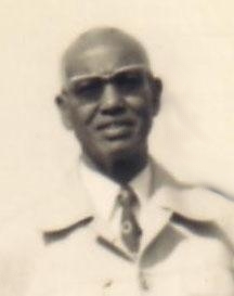
Picture of Hassan Gouled Aptidon, the first President of Djibouti. By Unknown author - The photograph, taken in 1977, is from http://www.spp.dj/articlemartinet26112006.html. Transferred from en.wikipedia; transferred to Commons by User:Kelly using CommonsHelper., Public domain, https://commons.wikimedia.org/w/index.php?curid=12478498
1981 CE
One-party state declared
President Gouled's RPP becomes the sole legal political party, consolidating power and banning opposition parties. Source — Wikipedia, "Djibouti":
Flag of Djibouti By Unknown author - From the Open Clip Art website., Public domain, https://commons.wikimedia.org/w/index.php?curid=433103
Nov 1, 1991 CE
FRUD rebellion begins
The Front for the Restoration of Unity and Democracy, led by Afar rebels, launches an armed insurgency against the government. Source — Wikipedia, "Djibouti":
Flag of the Front for the Restoration of Unity and Democracy (FRUD). By Germenfer - Own work, Public domain, https://commons.wikimedia.org/w/index.php?curid=103193484
Sep 1, 1992 CE
Multi-party constitution
A new constitution introduces multi-party politics, though the civil war continues in the northern Afar regions. Source — Wikipedia, "Djibouti":
Replacement for the PNG version of the en:Djibouti arms By Zscout370 at English Wikipedia - Transferred from en.wikipedia to Commons. Transfer was stated to be made by User:Mohau., Public domain, https://commons.wikimedia.org/w/index.php?curid=3030673
Dec 1, 1994 CE
Peace accord signed
The government signs a peace agreement with moderate FRUD factions, ending most hostilities and granting political concessions. Source — Wikipedia, "Djibouti":
Flag of the Front for the Restoration of Unity and Democracy (FRUD). By Germenfer - Own work, Public domain, https://commons.wikimedia.org/w/index.php?curid=103193484
Apr 1, 1999 CE
Guelleh elected president
Ismail Omar Guelleh, handpicked successor of Hassan Gouled, wins the presidential election amid the first peaceful leadership transition. Source — Wikipedia, "Djibouti":
The President of Djibouti, Mr. Ismail Omar Guelleh, at the International Solar Alliance (ISA) Summit, in New Delhi on March 11, 2018. By Prime Minister's Office - This file or its source was published by Press Information Bureau on behalf of Prime Minister's Office, Government of India under the ID 123254 and CNR 110709. (direct link) This tag does not indicate the copyright status of the attached work. A normal copyright tag is still required. See Commons:Licensing. العربية ∙ বাংলা ∙ English ∙ हिन्दी ∙ 日本語 ∙ македонски ∙ മലയാളം ∙ polski ∙ தமிழ் ∙ ತುಳು ∙ 中文 ∙ 中文(简体) ∙ 中文(繁體) ∙ +/−, GODL-India, https://commons.wikimedia.org/w/index.php?curid=103408203
May 1, 2001 CE
Final peace agreement
A comprehensive peace accord is signed with remaining FRUD factions, formally ending the decade-long civil conflict. Source — Wikipedia, "Djibouti":
Flag of the Front for the Restoration of Unity and Democracy (FRUD). By Germenfer - Own work, Public domain, https://commons.wikimedia.org/w/index.php?curid=103193484
Jun 1, 2008 CE
Eritrea border clash
Djibouti and Eritrea clash along the disputed Ras Doumeira border, resulting in dozens of casualties and international condemnation. Source — Wikipedia, "Djibouti":
Shaded relief map of Djibouti, original from 1991, with the border between Ethiopia and Eritrea added in 2006. By CIA - [1] from the Perry-Castañeda Library Map Collection., Public domain, https://commons.wikimedia.org/w/index.php?curid=4220606
Apr 1, 2010 CE
Term limits removed
A constitutional referendum removes the two-term limit, allowing President Guelleh to seek additional terms in office. Source — Wikipedia, "Djibouti":
Flag of Djibouti By Unknown author - From the Open Clip Art website., Public domain, https://commons.wikimedia.org/w/index.php?curid=433103
Feb 1, 2011 CE
Arab Spring protests
Protests inspired by the Arab Spring erupt in Djibouti, with demonstrators demanding political reform and Guelleh's resignation. Source — Wikipedia, "Djibouti":
Map of Djibouti, Arab States. By Xiquet - Own work, Public domain, https://commons.wikimedia.org/w/index.php?curid=3301834
Aug 1, 2017 CE
China opens military base
China opens its first overseas military base in Djibouti, joining France, the United States, and Japan with military installations in the country. Source — Wikipedia, "Djibouti":
Flag of Djibouti By Unknown author - From the Open Clip Art website., Public domain, https://commons.wikimedia.org/w/index.php?curid=433103
Apr 1, 2021 CE
Guelleh wins fifth term
President Ismail Omar Guelleh is reelected for a fifth term with over 97% of the vote amid opposition boycotts. Source — Wikipedia, "Djibouti":
Replacement for the PNG version of the en:Djibouti arms By Zscout370 at English Wikipedia - Transferred from en.wikipedia to Commons. Transfer was stated to be made by User:Mohau., Public domain, https://commons.wikimedia.org/w/index.php?curid=3030673