Encyclopedia/3. History, Societies & Civilizations/09. Modern Nations/03. Central Asia • Curated by Admin Timeline.sg
History of Kyrgyzstan (AI-generated, sourced to Wikipedia).
Chronological Storyline (28 Milestones)
700 BCE
Scythian nomads roam region
Iranian-speaking Saka and Scythian nomadic tribes inhabited the Tien Shan and surrounding steppes, leaving behind petroglyphs and kurgan burials. Source — Wikipedia, "Kyrgyzstan":
Extent of the Scythian kingdom in Western Asia and Europe By Antiquistik - Own work based on: Barnett, R. D. (1991) "Urartu" in The Cambridge Ancient History, 3.1, Cambridge: Cambridge University Press, pp. 314–371 ISBN: 978-1-139-05428-7. Batty, Roger (2007) Rome and the Nomads: The Pontic-Danubian Realm in Antiquity, Oxford: Oxford University Press, pp. 204−214 ISBN: 978-0-198-14936-1. Brinkman (1991) "Babylonia in the Shadow of Assyria" in The Cambridge Ancient History, 3.2, Cambridge: Cambridge University Press, pp. 1−70 ISBN: 978-1-139-05429-4. Diakonoff, I. M. (1985) "Media" in The Cambridge History of Iran: Volume, 2, Cambridge: Cambridge University Press ISBN: 978-0-521-20091-2. Grayson, A. K. (1991) "Assyria: Sennacherib and Esarhaddon" in The Cambridge Ancient History, 3.2, Cambridge: Cambridge University Press, pp. 103–141 ISBN: 978-1-139-05429-4. Grousset, René (1970) The Empire of the Steppes, Rutgers University Press ISBN: 0-8135-1304-9. Harmatta, János (1996) "The Scythians" in History of Humanity: From the seventh century B.C. to the seventh century A.D., 3, UNESCO, pp. 181–182 ISBN: 923102812X. Hawkins, J. D. (1991) "The Neo-Hittite States in Syria and Anatolia" in The Cambridge Ancient History, 3, Cambridge: Cambridge University Press, pp. 372−441 ISBN: 978-1-139-05428-7. Ivantchik, Askold (1993) (in French) Les Cimmériens au Proche-Orient, Fribourg, Switzerland; Göttingen, Germany: Editions Universitaires (Switzerland); Vandenhoeck & Ruprecht (Germany) ISBN: 978-3-727-80876-0. Ivantchik, Askold (2018). Scythians. Encyclopædia Iranica. Loehr, Max (1955). "The Stag Image in Scythia and the Far East". Archives of the Chinese Art Society of America 9: 63-76. Chinese Art Society of America. Olbrycht, Marek Jan (2000) "Remarks on the Presence of Iranian Peoples in Europe and Their Asiatic Relations" in Collectanea Celto-Asiatica Cracoviensia, Kraków: Księgarnia Akademicka, pp. 101–140 ISBN: 978-8-371-88337-8. Olbrycht, Marek Jan (2000) "The Cimmerian Problem Re-Examined: the Evidence of the Classical Sources" in Collectanea Celto-Asiatica Cracoviensia, Kraków: Księgarnia Akademicka, pp. 71−99 ISBN: 978-8-371-88337-8. Phillips, E. D. (1972). "The Scythian Domination in Western Asia: Its Record in History, Scripture and Archaeology". World Archaeology 4 (2): 129–138. DOI:10.1080/00438243.1972.9979527. Spalinger, Anthony J. (1978). "The Date of the Death of Gyges and Its Historical Implications". Journal of the American Oriental Society 98 (4): 400–409. DOI:10.2307/599752. Spalinger, Anthony (1978). "Psammetichus, King of Egypt: II". Journal of the American Research Center in Egypt 15: 49–57. DOI:10.2307/40000130. Sulimirski, T. (1954). "Scythian Antiquities in Western Asia". Artibus Asiae 17 (3): 282-318. Ascona, Switzerland: Artibus Asiae Publishers. ; Tadeusz Sulimirski, T. F. Taylor (1991) "The Scythians" in The Cambridge Ancient History, 3.2, Cambridge: Cambridge University Press, pp. 547–590 ISBN: 978-1-139-05429-4. Tokhtas’ev, Sergei R. (1991). Cimmerians. Encyclopædia Iranica. Vaggione, Richard P. (1973). "Over All Asia? The Extent of the Scythian Domination in Herodotus". Journal of Biblical Literature 92 (4): 523-530. DOI:10.2307/3263121. Young, T. Cuyler (1988) "The early history of the Medes and the Persians and the Achaemenid empire to the death of Cambyses" in The Cambridge Ancient History, 4, Cambridge: Cambridge University Press, pp. 1–52 ISBN: 978-0-521-22804-6. Background from [1], CC BY-SA 4.0, https://commons.wikimedia.org/w/index.php?curid=122424291
552 CE
Turkic Khaganate established
The Göktürks founded the First Turkic Khaganate, bringing the ancestors of the Kyrgyz under Turkic political and cultural influence. Source — Wikipedia, "Kyrgyzstan":
The flag of Kyrgyzstan By Shakiev N.T., Primov U.B. - http://kenesh.kg/ru/draftlaw/644212/show; updated with approved specifications, Public domain, https://commons.wikimedia.org/w/index.php?curid=142706251
840 CE
Yenisei Kyrgyz defeat Uyghurs
The Yenisei Kyrgyz overthrew the Uyghur Khaganate in Mongolia, establishing a brief Kyrgyz great power in the steppe. Source — Wikipedia, "Kyrgyzstan":
The flag of Kyrgyzstan By Shakiev N.T., Primov U.B. - http://kenesh.kg/ru/draftlaw/644212/show; updated with approved specifications, Public domain, https://commons.wikimedia.org/w/index.php?curid=142706251
960 CE
Karakhanids adopt Islam
The Karakhanid Khanate, ruling parts of the Kyrgyz heartland, became the first Turkic dynasty to officially convert to Islam. Source — Wikipedia, "Kyrgyzstan":
The flag of Kyrgyzstan By Shakiev N.T., Primov U.B. - http://kenesh.kg/ru/draftlaw/644212/show; updated with approved specifications, Public domain, https://commons.wikimedia.org/w/index.php?curid=142706251
1219 CE
Mongol invasion reaches region
Genghis Khan's armies swept through the Tien Shan, subjugating the Kyrgyz tribes and incorporating them into the Mongol Empire. Source — Wikipedia, "Kyrgyzstan":
Map of the Mongol Empire's territorial expansion in 1206-1294. Shows the territory of the Mongol Empire when Genghis Khan unified the tribes, mainly on the Mongolian plateau, including the regions of the Kereit, Naiman and Merkit. By DannamEmpire - Own work, CC BY 4.0, https://commons.wikimedia.org/w/index.php?curid=162865370
1380 CE
Timurids dominate region
Tamerlane's Timurid Empire exerted control over the Kyrgyz lands, with the city of Osh serving as a regional center. Source — Wikipedia, "Kyrgyzstan":
Timur's empire at his death, vasals aren't shown. By Stuntelaar - Own work, CC BY-SA 3.0, https://commons.wikimedia.org/w/index.php?curid=5206128
1500 CE
Kyrgyz migrate to Tien Shan
Kyrgyz tribes gradually migrated from the Altai and Yenisei regions to their present-day Tien Shan homeland over the 15th and 16th centuries. Source — Wikipedia, "Kyrgyzstan":
Kyrgyz man with ak-kalpak ("white-kalpak") hat, made of wool. Mens national hat of Kyrgyzstan, UNESCO Intangible Cultural Heritage (Reference:01496) By Petar Milošević - Own work, CC BY-SA 4.0, https://commons.wikimedia.org/w/index.php?curid=183109039
1685 CE
Kyrgyz resist Dzungar raids
Kyrgyz tribes fought against Dzungar Mongol incursions, maintaining a fragile independence in the mountainous Tien Shan region. Source — Wikipedia, "Kyrgyzstan":
The Map of the Dzungar Khanate, in the year 1717, which was their nation's territory peak under Tsewng Rabtan Khan. The exact date is after the Khoshut Khanate's destruction, and the Dzungar capture of Lhasa. Credits to User:पाटलिपुत्र for base of the map, as he uploaded under CC-BY-SA 4.0, and naturalearthdata.com, offered to the Public Domain By HorseBro the hemionus - Own work, Credits to User:पाटलिपुत्र for base of the map, as he uploaded under CC-BY-SA 4.0, and naturalearthdata.com, offered to the Public Domain Sources: According to Ciuqin, the Dzungar Khanate had initially extended from the Irtysh to the Sali Mountains, and the Boke River. They later extended to the Ili River, they soon remained on the region north of Tian Shan, followed by Torghut–Dorbet migration to Volga, and the Khoshut migration to Qinghai.[1] The Dzungars did not own the Western Bank of the Irtysh, as the Yesim Khan of the Kazakh Khanate had expulsed the Oirats from the Western Banks, during a civil war between Chokhur and Torobaikhu/Gushi Khan.[2] Later, the Oirats expanded deep into the Altai Mountains, and the Yenisei during Sengge Chechen Khong Tayiji's rule, as the Dzungars annexed the Altan Khan of the Khalkhas, and vassalized the Kyrgyz people that resided in the Area.[3] Soon the Dzungars expanded into the Biya, and Katun Rivers as they destroyed a Russian fortress between them, while they also ravaged Russian towns in the area.[4] The Dzungars soon expanded southwards, as they conquered the Tarim Basin from 1679–1680,[5] and Tibet from 1717–1720.[6], CC BY-SA 4.0, https://commons.wikimedia.org/w/index.php?curid=183984425
1822 CE
Kokand Khanate conquers Kyrgyz
The Khanate of Kokand gradually subdued the northern Kyrgyz tribes, building fortresses like Pishpek and Tokmak to consolidate control. Source — Wikipedia, "Kyrgyzstan":
The banner of the Kokand khans was white (aq-yalaw or just yalaw), symbolising the Chingissid tradition of khan authority. By Incall - Own work; Timur, Beysembiev (2009) (in Russian) Kokand historiography: a study on the source study of Central Asia in the XVIII-XIX centuries, Print-S, p. 161 ISBN: 978-9965-482-84-7. Tursunov, Buston (2014) (in Russian) Military state of the Russian Empire and the Kokand Khanate in the conquest of Central Asia (conquest plans, armament, numerical composition of the army of the parties in the mid-19th century), p. 223, Public domain, https://commons.wikimedia.org/w/index.php?curid=153788004
1876 CE
Russian Empire annexes region
Russia dissolved the Kokand Khanate and incorporated the Kyrgyz lands into the Russian Empire as part of Turkestan Governorate-General. Source — Wikipedia, "Kyrgyzstan":
Набег казаков на поселение туземцев By Nikolay Karazin - https://art.mirtesen.ru/blog/43646912712/Hudozhnik-Nikolay-Nikolayevich-Karazin.?utm_referrer=mirtesen.ru, Public domain, https://commons.wikimedia.org/w/index.php?curid=90982513
Jul 1, 1916 CE
Central Asian revolt erupts
Kyrgyz and other Central Asian peoples rose against Tsarist conscription orders, resulting in violent suppression and mass flight to China known as Urkun. Source — Wikipedia, "Kyrgyzstan":
Kyrgyz refugees fleeing the Russian Empire for China following the defeat of the Central Asian revolt of 1916. By Unknown author - https://eurasianet.org/kyrgyzstan-historical-debate-straining-ties-russia, Public domain, https://commons.wikimedia.org/w/index.php?curid=163848509
1918 CE
Soviet rule established
The Kyrgyz lands became part of the Turkestan Autonomous Soviet Socialist Republic within the Russian SFSR following the Bolshevik Revolution. Source — Wikipedia, "Kyrgyzstan":
Turkestan Autonomous SSR Flag By ЦИК ТССР - Туркестан, Public domain, https://commons.wikimedia.org/w/index.php?curid=115637086
Oct 1, 1924 CE
Kara-Kyrgyz Oblast created
The Kara-Kyrgyz Autonomous Oblast was established within the Russian SFSR, recognizing the Kyrgyz as a distinct nationality. Source — Wikipedia, "Kyrgyzstan":
Карта республик и областей Средней Азии до и после национального размежевания из книги Рамзин, К. Революция в Средней Азии. М.: Издательство Саку, 1928. [12] с., 125 л. ил.; 270х350 мм. 5000 экз. By K. Ramzin - Рамзин, К. Революция в Средней Азии. М.: Издательство Саку, 1928., Public domain, https://commons.wikimedia.org/w/index.php?curid=66335440
1926 CE
Kyrgyz ASSR established
The Kara-Kyrgyz Autonomous Oblast was upgraded to the Kyrgyz Autonomous Soviet Socialist Republic, with Frunze (Bishkek) as its capital. Source — Wikipedia, "Kyrgyzstan":
The flag of Kyrgyzstan By Shakiev N.T., Primov U.B. - http://kenesh.kg/ru/draftlaw/644212/show; updated with approved specifications, Public domain, https://commons.wikimedia.org/w/index.php?curid=142706251
Dec 1, 1936 CE
Kyrgyz SSR becomes union republic
Kyrgyzstan was elevated to a full Union Republic of the Soviet Union, gaining nominal sovereignty within the USSR. Source — Wikipedia, "Kyrgyzstan":
Kyrgyz SSR becomes union republic By Unknown author, Public domain, https://commons.wikimedia.org/w/index.php?curid=961556
1961 CE
Issyk-Kul petroglyphs discovered
Ancient petroglyphs at Cholpon-Ata on Lake Issyk-Kul, dating from the second millennium BCE, gained scholarly attention as a major archaeological site. Source — Wikipedia, "Kyrgyzstan":
A view of Rukh Ordo in Cholpon-Ata, Kyrgyzstan, from the southeast. By Firespeaker - Own work, CC BY-SA 4.0, https://commons.wikimedia.org/w/index.php?curid=66144741
Jun 1, 1990 CE
Osh ethnic riots occur
Violent clashes between ethnic Kyrgyz and Uzbeks in Osh and Uzgen killed hundreds, foreshadowing post-Soviet ethnic tensions. Source — Wikipedia, "Kyrgyzstan":
The flag of Kyrgyzstan By Shakiev N.T., Primov U.B. - http://kenesh.kg/ru/draftlaw/644212/show; updated with approved specifications, Public domain, https://commons.wikimedia.org/w/index.php?curid=142706251
Aug 31, 1991 CE
Kyrgyzstan declares independence
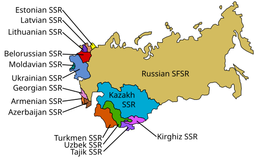
Following the failed Moscow coup, the Kyrgyz Supreme Soviet declared independence from the Soviet Union. Source — Wikipedia, "Kyrgyzstan":
A map of the Soviet Union, with its constituent Soviet Socialist Republics labeled. By Special:Contributions/Saul ip. Derivative work by Σ (talk) - File:USSR map.svg, CC BY-SA 3.0, https://commons.wikimedia.org/w/index.php?curid=17162429
Mar 1, 1992 CE
Kyrgyzstan joins United Nations
The newly independent Kyrgyzstan was admitted to the United Nations, securing international recognition as a sovereign state. Source — Wikipedia, "Kyrgyzstan":
The flag of Kyrgyzstan By Shakiev N.T., Primov U.B. - http://kenesh.kg/ru/draftlaw/644212/show; updated with approved specifications, Public domain, https://commons.wikimedia.org/w/index.php?curid=142706251
1995 CE
Manas epic UNESCO recognition
The Epic of Manas, a traditional Kyrgyz oral poem spanning over 500,000 lines, gained international attention as one of the world's longest epics. Source — Wikipedia, "Kyrgyzstan":
The flag of Kyrgyzstan By Shakiev N.T., Primov U.B. - http://kenesh.kg/ru/draftlaw/644212/show; updated with approved specifications, Public domain, https://commons.wikimedia.org/w/index.php?curid=142706251
Mar 1, 2005 CE
Tulip Revolution ousts Akayev
Mass protests against electoral fraud and corruption forced President Askar Akayev to flee, ushering in Kurmanbek Bakiyev. Source — Wikipedia, "Kyrgyzstan":
The flag of Kyrgyzstan By Shakiev N.T., Primov U.B. - http://kenesh.kg/ru/draftlaw/644212/show; updated with approved specifications, Public domain, https://commons.wikimedia.org/w/index.php?curid=142706251
Apr 1, 2010 CE
Second Kyrgyz Revolution
Bloody protests in Bishkek toppled President Bakiyev, leading to a provisional government under Roza Otunbayeva. Source — Wikipedia, "Kyrgyzstan":
An opposition-captured vehicle burns near the capitol building during citywide protests and riots in Bishkek, Kyrgyzstan on April 7th, 2010. Guards can be seen to the left of the smoke. By Brokev03 - Own work, CC BY-SA 3.0, https://commons.wikimedia.org/w/index.php?curid=9979657
Jun 27, 2010 CE
New constitution approved
A referendum established Kyrgyzstan as a parliamentary republic, making it Central Asia's first parliamentary democracy. Source — Wikipedia, "Kyrgyzstan":
The State Emblem of the Kyrgyz Republic. By А. Абдраев (A. Abdraev), С. Дубанаев (S. Dubanaev) 1994. Standardized version:Nurbek Nasyranbekov Nargiza Kulataeva, Kanat Karapashov, Marcel Sheishenov(2016). - https://grs.gov.kg/kg/eid/state_symbols/ and https://medium.com/@nurbek/как-мы-рисовали-герб-a4f46a94463d, Public domain, https://commons.wikimedia.org/w/index.php?curid=52584783
Jun 1, 2010 CE
Osh violence erupts again
Renewed ethnic violence between Kyrgyz and Uzbeks in southern Kyrgyzstan killed over 400 people and displaced tens of thousands. Source — Wikipedia, "Kyrgyzstan":
View from Sulayman Mountain in Osh, Kyrgyzstan By A.Savin - Own work, FAL, https://commons.wikimedia.org/w/index.php?curid=49645427
2011 CE
Suleyman Mountain UNESCO listing
Sulayman Mountain in Osh, a sacred site for centuries, was inscribed as Kyrgyzstan's first UNESCO World Heritage Site. Source — Wikipedia, "Kyrgyzstan":
Sulayman Mountain in Osh, Kyrgyzstan By A.Savin - Own work, FAL, https://commons.wikimedia.org/w/index.php?curid=49531029
Aug 1, 2015 CE
Kyrgyzstan joins Eurasian Union
Kyrgyzstan formally became a member of the Eurasian Economic Union, deepening economic ties with Russia and neighbors. Source — Wikipedia, "Kyrgyzstan":
Flag of the Eurasian Economic Union. By Eurasian Commission vector version by Thommy - Own work Решение № 76 «Об утверждении Положения о символике Евразийского экономического союза» Map of Eurasia: Natural Earth, Public domain, https://commons.wikimedia.org/w/index.php?curid=37389088
Oct 1, 2020 CE
Third revolution removes Jeenbekov
Protests over parliamentary election results led to the resignation of President Sooronbay Jeenbekov, bringing Sadyr Japarov to power. Source — Wikipedia, "Kyrgyzstan":
Бишкектеги 5—6 октябрда Жогорку Кеңешке шайлоонун жыйынтыктарына байланыштуу өткөн нааразычылык митинг милиция кызматкерлери менен кагылышуусу менен уланып «Ак үйдүн» басып алуусу менен жыйынтыкталган. Аны менен саясий кризис аяктабай уландысын алат. By Isakov077 - Own work, CC BY-SA 4.0, https://commons.wikimedia.org/w/index.php?curid=94893840
Apr 1, 2021 CE
Presidential system restored
A constitutional referendum shifted Kyrgyzstan back to a strong presidential system, consolidating executive power under Japarov. Source — Wikipedia, "Kyrgyzstan":
The State Emblem of the Kyrgyz Republic. By А. Абдраев (A. Abdraev), С. Дубанаев (S. Dubanaev) 1994. Standardized version:Nurbek Nasyranbekov Nargiza Kulataeva, Kanat Karapashov, Marcel Sheishenov(2016). - https://grs.gov.kg/kg/eid/state_symbols/ and https://medium.com/@nurbek/как-мы-рисовали-герб-a4f46a94463d, Public domain, https://commons.wikimedia.org/w/index.php?curid=52584783


![Карта республик и областей Средней Азии до и после национального размежевания из книги Рамзин, К. Революция в Средней Азии. М.: Издательство Саку, 1928. [12] с., 125 л. ил.; 270х350 мм. 5000 экз.](https://upload.wikimedia.org/wikipedia/commons/thumb/7/78/National_delimitation_in_Middle_Asia.jpg/500px-National_delimitation_in_Middle_Asia.jpg)